The urban structure of Atina originates in medieval times and is centered on the Church of the Assumption built on the temple of Saturn and on the palace built by the Dukes of Cantelmo in the fourteenth century on a pre-existing fortress; this first urban nucleus was served by three main roads that are still connected with narrow steps to what remains of the circle of walls and to its tower-houses.
Urban development continues in the seventeenth and eighteenth centuries, in fact in this period the urban fabric expands beyond the walls and is enriched with noble palaces and new churches.
Unfortunately, little remains of the important period of the imperial and republican era.
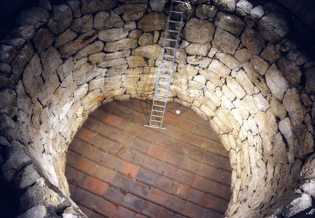
The urban excavations of autumn 2006 brought to light, at a depth of 3m from the current floor of the square, a large elliptical cistern, built in polygonal work, with blocks still perfectly connected. The floor, discovered only with a limited essay, which has reached a depth of 8m, is made up of flat tiles, carefully placed side by side.
The structure's water collection function is emphasised by its topographical location in a natural valley area, enclosed between the hill of S. Stefano to the east (the acropolis) and the height of the current historic centre to the west.
It is also possible to hypothesise a functional connection of this structure with the Roman aqueduct of the early imperial age, which entered the city near the cistern: the historiographical tradition of Atinate in fact tells that a “large vase of stones worked with many lead aquiducts” it was visible in the square in 1700 (“Historical memories of the ancient city of Atina” - Tauleri Bonaventura - Naples 1702), therefore a castellum aquae.
In Roman times and precisely in the first century. AD, an aqueduct had actually been built in Atina which, through underground conduits and after having travelled a stretch of about 8km, flowed into a terminal basin called castellum aquae, obviously located in an upper area of the city, which through a series of pipelines distributed the water in fountains and cisterns arranged in various points of the city, after an appropriate period of decantation and purification of the water itself.
From the castellum aquae, an underground conduit made the water flow into a distribution manifold that the historian Buonaventura Tauleri thus describes in his volume on Atina of 1702:
“It reached the Piazza della Città, where for the convenience of the citizens and of those who contributed to it, in a large vase of worked stones, still standing ..., it congregated and then branched off, with many lead aqueducts, in different parts of this City , nor Gardens and Fields of the same “
In support of what Tauleri wrote, in the immediate post-war period two large water collection tanks were still visible in Piazza Garibaldi, which were then filled with material from the rubble of the houses and disappeared following post-war reconstructions.
The tank found in 2006, due to its lower altitude compared to the ancient floors, must be identified as the tank used for decanting the waters before their introduction into the castellum aquae which had to rise right next to the Porta dell'Assunta, the current entrance to the historical centre and one of the highest points of the urban fabric.